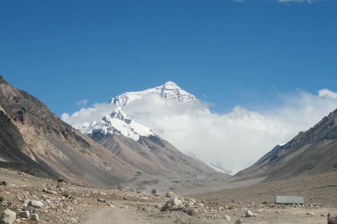
Mount Everest is also the highest mountain in the world, at 8,848.86m (29,031.7 ft) above sea level. It is situated in the Himalayan Mountain range, straddling the border between Nepal and Tibet, China.
In the Nepali language, it is known as Sagarmatha, which means ‘Head of the Sky’; in Tibetan, Chomolungma means ‘Goddess Mother of the World’; the peak known as Mount Everest has now become the world’s most challenging climb.
Mount Everest is popular with visitors due to its altitude, extreme weather, and stunning views. It is a famous destination for trekking and climbing for many tourists worldwide, and everyone aims to conquer the top of the mountain.
It is situated in the greater area of the Sagarmatha National Park in Nepal, a world heritage site and snow-capped Mountain region with glaciers, steep valleys, and other eye-catching terrains.
Climbing Mount Everest is evil and terrible because several factors predispose one to health complications. However, Everest is one of the most popular destinations for mountaineering and hiking enthusiasts because it offers the chance to confront the highest peak on Earth.
Where Is Mount Everest's Country Located on a Map?
Mount Everest, the tallest mountain in the world, is in Nepal, a scenic landlocked country in South Asia. Nepal is bounded south by India and north by China. On the map, Nepal is a small country shaped like a rectangle in the Himalayas.
Nepal claims to be home to eight of the world's fourteen highest peaks, including Everest. Mount Everest sits on the border of Nepal and the Tibet Autonomous Region of China in northeastern Nepal.
Mount Everest is a Tibetan Himalayan mountain located on the country's northern frontier. Its precise location is 27°59'17" N and 86°55'31" E, and it is accessible through maps of the Himalayan area.
Himalayan Region, Hilly Region, and Terai Region. Mount Everest is located in the Himalayan Range, particularly in the Sagarmatha National Park, a UNESCO World Heritage Site. The area is renowned for its breathtaking panoramas and glacial and high-altitude walks.
Nepal's capital, Kathmandu, is approximately 160 km southwest of Mount Everest. Travellers and mountaineers planning to go to Everest first originate from Lukla, a small place (reachable by a short flight from Kathmandu).
Examples are presented where maps are employed to elevate Lukla as the "doorway" to Everest, and the route to the Everest base camp trek is easy to navigate.
Where Is Mount Everest Country Located In Asia?
Mount Everest is in Nepal, a small, scenic South Asian country. Nepal borders on south, east, and west (India), west (India), and north (China). In the landscape of Asia, one can see the country of Nepal, situated in the foothills of the Himalayas, which has the highest mountain system in the world.
Nepal is an ecologically relevant region located in the central region of the Asian mainland, and thus, it also has a crucial role in the South Asian region. It is shaped like a rectangle and is entirely landlocked, meaning it has no access to the sea. Mount Everest is located in northeast Nepal, bordering Tibet, an autonomous region within China.
The Himalayan zone of Nepal is the home of Mount Everest and numerous other high mountains. This area encompasses the northernmost part of the country, including Sagarmatha National Park, a United Nations Educational, Scientific and Cultural Organization (UNESCO) World Heritage site, which houses Mount Everest.
In this region, Nepal and Asia have treasures for their beautiful scenery. On a map of Asia, Nepal is eminent due to its altitude, verdant valley, and colourful culture. Mount Everest, also known as Sagarmatha in Nepali and Chomolungma in Tibetan, is the crown jewel of this land, symbolizing the natural beauty of Nepal and the Asian continent.
Where is Mount Everest located in Nepal?
Mount Everest is located in northeastern Nepal, in the Sagarmatha National Park in the Solukhumbu District of Province 1. The mountain lies along the border between Nepal and Tibet, an autonomous region of China. The summit's specific coordinates are 27°59′17″ North latitude and 86°55′31″ East longitude.
In Nepal, the mountain is known as Sagarmatha, which means "Head of the Sky" in Nepali. The Everest region is renowned for its stunning landscapes, including rugged mountain terrain, glaciers, and deep valleys.
The Everest Base Camp, a popular trekking destination, is located at about 5,364 meters (17,598 feet) and is the starting point for climbers attempting to summit the mountain.
This area is part of the larger Khumbu region, home to the famous Sherpa people, known for their climbing expertise. The Everest region is accessible through Lukla, a small town with an airport, which serves as the primary gateway for trekkers and climbers heading toward Mount Everest.
What Countries Surround Mount Everest?
Nepal and the Tibet Autonomous Region of China abut the mountain on all sides. The frontier borders the summit of Mount Everest, so climbers who are native to either country can reach the summit from either side of the frontier.
Nepal (Southern Side) Nepal lies to the south of Mount Everest. The mountain is in Nepal's Sagarmatha National Park, a UNESCO World Heritage area in the Himalayan Arc.
The South Face, the Nepalese face of Everest, is the most visited route for climbers. The country is equally famous for its breathtaking views of nature, the richness of its culture, and the tourism under the base camp trekking of Everest.
Villages such as Lukla and Namche Bazaar play essential roles as access points for treks. Tibet, China (Northern Side) To the north of Mount Everest lies Tibet, an autonomous region of China. The north face of Everest is reachable from Tibet, and climbers can access the base camp near Rongbuk Monastery.
The Tibetan approach provides a unique view of the mountain, as the scenery of the high-altitude plains dominates its bowl-like summit. Tibet is known for its Buddhist culture and its stunning plateau views. India's Proximity Although Mount Everest does not reside in India, the country is to the south of Nepal and is geographically close to it.
Many climbers travelling to Nepal pass through India, and the Himalayan peaks extend into the northernmost part of the Indian subcontinent (e.g., Sikkim and Uttarakhand). These three countries—Nepal, China (Tibet), and India—form the core region surrounding Mount Everest and the greater Himalayas.
Mount Everest, Location and Height
Mount Everest is in the Himalayan mountain range at the Nepal and Tibet Autonomous Region of China border. Its exact coordinates are 27°59′17″ N latitude, 86°55′31″ E longitude. In Nepal, it is in/around Sagarmatha National Park and near Rongbuk Glacier in Tibet.
Mount Everest is the largest mountain on Earth, with an officially recorded summit height of 8,848.86 m (29,031.7 ft) above sea level. A bilateral survey conducted by Nepal and China updated this estimate in 2020.
The mountain is named Sagarmatha in Nepal, "Head of the Sky," and Chomolungma in Tibetan, "House of Mother/Goddess of the World." The route above the South Col from Nepal and the North Col from Tibet offers incredible but challenging paths to the peak.
Mount Everest is the glittering crown of the Himalayas and one of the most universally respected icons of nature's magnificence and human daring. It is one of those holy places that attracts climbers, trekkers and explorers worldwide every year.
Mount Everest Absolute Location
The exact location of Mount Everest is given as follows:
Latitude: 27°59'17" North
Longitude: 86°55'31" East
This Mount Everest location is at the summit of the Himalayan range on the border of Nepal and Tibet, the autonomous region of China. Mount Everest is a natural border between the two areas as its summit constitutes the region's highest peak.
The mountain area is in Sagarmatha National Park, Nepal, a Site of Outstanding Universal Value in the context of globally rich wildlife, glaciers and majestic mountain peaks. Its Tibetan side lies very close to the Rongbuk Glacier, which still provides another perspective on the magnificent mountain.
The absolute coordinates place Mount Everest at the highest altitude on the Earth, 8,848.86 m (29,031.7 ft) above sea level, and in the centre of one of the most familiar natural scenery.
Known Location Of Bodies On Mount Everest
The summit of Mount Everest, the highest mountain in the world, has also caused many climbers' deaths over the years. Due to the very harsh climate (low temperature and high altitude), climbers who die are usually left stranded on the mountain and are frozen in place. In these zones, corpses have been found in Mount Everest:
1. The Death Zone (Above 8,000 meters)
"Death Zone" refers to an altitude area above 8,000 m with insufficient oxygen. The most significant mortality levels here result from fatigue, hypoxia, and abrupt weather events. The high risk makes it very difficult to recover bodies in this region. Some can still be seen on the climbing routes, a regretful reminder of the mountain's underworld.
2. Green Boots Cave
Green Boots is one of the most recognized geographic features on Everest. The corpse is known to Indian climber Tsewang Paljor. It is situated on top of a small cave on the Northeast Ridge trail. Climbers regularly see this human as they ascend to the summit from the Yamphu (the Tibetan side).
3. Rainbow Valley
Hidden just below the summit surface, Rainbow Valley is the nickname for the brightly coloured trip suits that climbers killed wearing. The site is famous for littering corpses up and down the slopes and, as a result, is both eerie and visually striking.
4. South Col
The South Col is a popular acclimatization site on the Nepali side before the final push to the summit. Several climbers of us die of altitude sickness or hypothermia. This zone, lying below the summit, sometimes provides a temporary refuge but, in turn, may also serve as a tomb for those who cannot go on.
5. Khumbu Icefall
Even at a relatively low altitude, the Khumbu Icefall, near the Everest Base Camp, is one of the most hazardous spots in the trek. In this place, there has been death by ice falling, sliding, or falling into a crevasse caused by the death of dozens of climbers and Sherpas.
These sites are disaster sites, but they are also warnings about the hazardous risks of climbing Mount Everest. Due to logistical barriers and the reasons people left, many bodies cannot be given a proper burial.
Where Is Mount Everest on Google Earth?
Mount Everest is located in the Himalayan mountain range, on the border between Nepal and the Tibet Autonomous Region of China, for a chance to see it on Google Earth.
In the bar, just input "27°59'17" N, 86°55'31" E. This will also state the exact location of the summit, which is the top of the Earth.
As soon as you zoom in with Google Earth, you will find Mount Everest's iconic pyramidal peak nestled among the more impressive peaks of the Himalayas. When the landscape is rocky and untamed, you can expansively view big glaciers.
Sagarmatha National Park and the Rongbuk Glacier, both in Nepal and Tibet, can also be localized. Zooming out slightly allows one to observe the neighbouring countries to both south Nepal and north China.
Experienced in using 3D imagery and images from Google Earth, the viewer can see Mount Everest through the browser and the possibility to travel track virtually, see the mountain from a different point of view, and follow the footprints of climbers.
Using Google Earth, you can take an accurate view of the position of Mount Everest and its role in the Himalayan massif, and you can then easily "travel" to the world's tallest mountain in the safety of your own house.


